


Reader Plates app for iPhone and iPad
Developer: Reader Plates LLC
First release : 21 Dec 2010
App size: 5.65 Mb
See what youve been missing with Reader Plates on your iPad. The app provides fast and easy access to U.S. approaches, arrivals, departures, airport diagrams, IFR enroute & VFR charts, weather & your own documents. One touch switches between an approach, arrival or departure, airport diagram, enroute chart, or your own checklist. Note: An active Reader Plates SUBSCRIPTION is REQUIRED for use.
Feature Highlights:
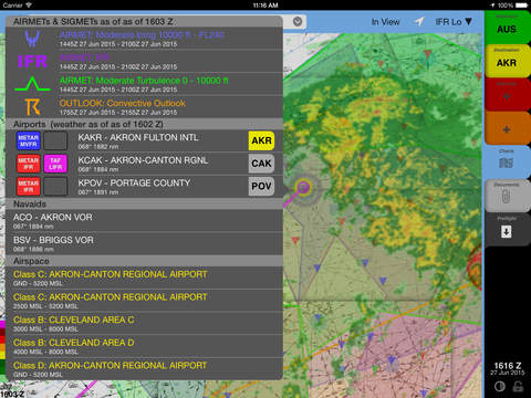
"Better Than Seamless" charts. Imagine cropping the margins and aligning every chart on a large wall. Then imagine the wall has the ability to instantly bring whatever chart you touch to the foreground.Touching the chart with two fingers displays the margins so you can see the Effective Dates and all the special airspace data that is only listed there. The benefits of seamless charts plus you get all of the information available on every chart. On top of that add see-through AIRMET, SIGMET, TFRs, weather radar, route lines & color-coded "Worst-Case TAF" indicators. Simply tap on the map for a list of conditions affecting that location and a list nearby airports & navaids with direction & distance to each.
Routes. Type waypoints & airways into the search bar or simply assign airports to the departure & destination tabs to create a route. Select routes from the history and tabs are automatically configured for departure, destination, & alternate. Drag route segments or waypoints to modify the route. "Slick" is description we keep hearing. Routes are planned using winds aloft forecasts & your own aircraft performance parameters. Choose your aircraft & departure time and enroute times are estimated for all applicable altitudes based on magnetic course and the aircrafts ceiling. "Direct To" shortcuts are as simple as rubber-banding the route segment to the current GPS position. (Continued use of GPS running in the background can dramatically decrease battery life.)
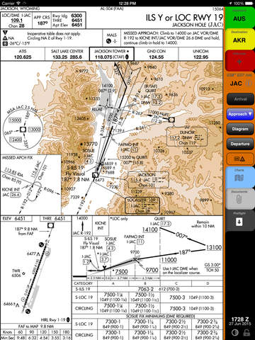
Instant access. Familiar colored tabs provide one-touch access to procedures for your departure, destination, & alternate airports. Each airport tab displays the current direction and distance to the airport and includes dedicated buttons for arrivals, approaches, departures, & the airport diagram. One-touch switches from your arrival procedure to your approach, then one more touch switches to the airport diagram. Last minute approach change? No problem, tap the Approach button and one touch selects a new approach from the list. Its easily done in less than two seconds. Plus IFR & VFR charts are also just a single-touch away and display almost instantly. And there is a tab for a scratchpad & your own PDF documents that is great for instant access to a checklist.
Fast, simple updates. A single glance at the Updates screen is all it takes to be sure you have current plates & charts. When its time for an update, just select the regions you need and tap the Update button. Every approach procedure, enroute, TAC, & sectional covering each selected region will be downloaded so it is accessible without an internet connection. Updates are FAST-- only changes since your last update are downloaded to drastically reduce the time spent downloading.
Complete and always accessible. Downloads include all U.S. SIDs, STARs, airport diagrams, minimums, approaches, legends, & Airport/Facility Directories. Hi & Lo Enroute charts, TAC, & Sectionals are included for the continental U.S. A paid subscription is required for downloading updates, but once downloaded there is no lock-out. Downloaded procedures & charts are marked expired when no longer effective, but are viewable until replaced or deleted regardless subscription status.
Sharp & easy to read. The default approach plate view is larger than life yet shows all the information youre likely to need without scrolling. And the text is still crisp & clear when zoomed to more than 2x actual size. Plus a single touch switches the entire display to night mode with white on black maps and darkened tabs & menus.